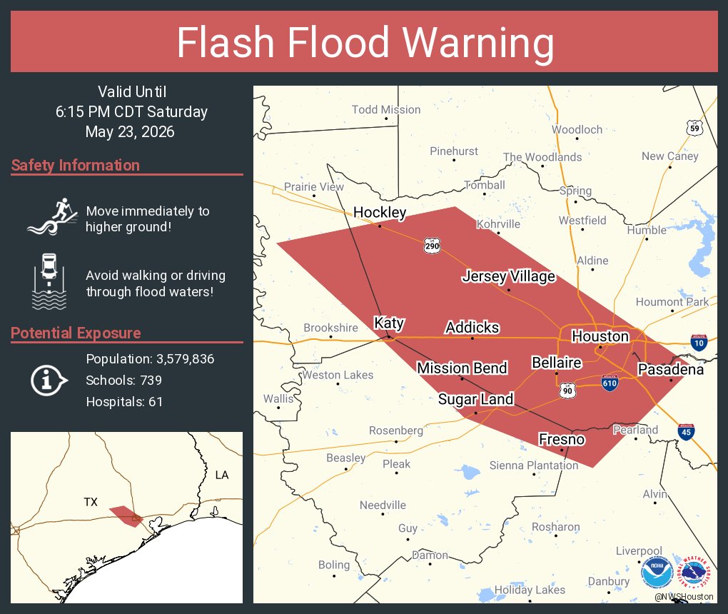

The highlighted region is under a flash flood warning until at least 6:15 p.m.
4:45 p.m. Update: A flash flood warning has been issued for parts of Harris, Brazoria, Fort Bend and Waller counties, the National Weather Service announced. The warning will last until at least 6:15 p.m.
Much of the Houston metro area is included in the flash flood warning, including downtown Houston, Pasadena, Sugar Land, Spring Valley Village, Katy, and Cypress. Between 2 and 3 inches of rain has already fallen in parts of the warned area, and an additional 1 to 2 inches is possible over the next two hours.
According to the National Weather Service, flash flooding will be possible across small creeks and streams, urban areas, highways, streets, underpasses, and other poor drainage and low-lying areas. Travel is highly discouraged. If you must travel, do not drive over flooded roadways.
Article continues below this ad
Rainfall is expected to last in Houston through 6 p.m. to 6:30 p.m. After that, drier conditions are likely for Saturday night.
Below is the full forecast for Saturday, May 23.

A flood watch remains in effect through Monday evening for portions of Southeast Texas, including Austin, Colorado, Waller, Harris, Liberty, Montgomery, Jackson, Matagorda, Wharton, Fort Bend, Brazoria, and Galveston counties.
Storm chances will ramp back up across the Houston area Saturday afternoon as repeated rounds of heavy rain threaten to bring localized flooding to parts of the Houston area through the remainder of Memorial Day weekend.
Flood watch: The National Weather Service on Friday expanded the area under their previously issued flood watch to encompass even more parts of Southeast Texas. Forecasters said they expect 2-4 inches of rainfall across the region, with isolated higher amounts of 5-6 inches through the holiday weekend. The flood watch is currently in effect through the Memorial Day holiday, ending at 7 p.m. Monday.
Article continues below this ad
Most of the Houston area has already picked up an inch to 3 inches of rain since Tuesday, with even higher totals south of the city, along the Texas Gulf Coast. While much of Saturday morning should feature only scattered showers and humid conditions, forecast models suggest a more widespread batch of storms could develop Saturday evening and linger into early Sunday.
WETTEST IN THE COUNTRY: Why Houston could rank among the soggiest places in the U.S. through Memorial Day weekend.
Because soils remain saturated from several days of rain, more downpours could quickly lead to street flooding and water pooling on roads in flood-prone neighborhoods or areas with poor drainage.

Saturday afternoon and evening could feature multiple rounds of thunderstorms across Southeast Texas, as shown by this future radar snapshot.
Memorial Day weekend: Storm chances ramp up late Saturday
Saturday may begin with only spotty showers and muggy conditions, but the flood threat is expected to increase significantly heading into the afternoon and evening as a more organized round of storms develops across Southeast Texas.
Article continues below this ad
Clouds and humidity will keep temperatures in the low to mid-80s through the afternoon. Scattered showers and storms are expected across the region between noon and 2 p.m., before more widespread rain arrives during the late afternoon and evening. The highest risk of storms is expected between 2 and 6 p.m.
Some storms could dump multiple inches of rain in a short period, especially in areas that have already been soaked by repeated rounds of rain this week. If storms repeatedly track over the same locations Saturday night, flash flooding, flooded streets and rapidly deteriorating travel conditions could develop across parts of the Houston area.
Houston and Galveston on Saturday and Sunday will be under a level 2 out of 4 risk, or at least a 15% chance, of excessive rainfall that could lead to flooding, according to the National Weather Service’s Weather Prediction Center.
Rain chances will start to decrease late Saturday night, especially after 9 p.m. However, some redevelopment overnight could result in additional rainfall, especially near and along the Gulf Coast.
Article continues below this ad

Houston on Saturday and Sunday will be under a level 2 out of 4 risk, or at least a 15% chance, of excessive rainfall that could lead to flooding, according to the National Weather Service’s Weather Prediction Center.
Outdoor plans should include a weather backup
If you have outdoor plans this weekend, make sure you have a nearby indoor shelter identified before storms develop. Keep phones charged and weather alerts enabled in case warnings are issued while you’re away from home.
HOUSTON WEATHER: Get weekly texts from meteorologist Justin Ballard when you sign up for Houston Weather [Simplified].
Article continues below this ad
Once thunderstorms approach, head indoors immediately if thunder is heard. Avoid open fields, metal bleachers, boats and isolated trees during lightning storms, and never drive through flooded roads where water depth may be difficult to judge.
Even after storms move out, dangerous lightning can linger for several minutes and flooded roads may remain impassable. Stay indoors until at least 30 minutes after the last rumble of thunder and use caution around downed tree limbs or power lines after heavier storms.