In their annual seasonal hurricane forecast for the northeast Pacific issued May 21, NOAA predicted an above-average 2026 hurricane season in both the eastern Pacific (for storms affecting Mexico) and the central Pacific (for storms affecting Hawaii). The eastern Pacific outlook calls for a 70% probability of 15-22 named storms, with 9-14 expected to become hurricanes, including 5-9 major hurricanes. Accumulated cyclone energy (ACE) is predicted to be 120-190% of the median. Using the midpoint of these ranges, NOAA is calling for 18.5 named storms, 11.5 hurricanes, and seven major hurricanes. These numbers are well above the 1991-2020 averages of 15 named storms, eight hurricanes, and four major hurricanes.
The main influence on this season’s outlook is the potentially powerful El Niño event now taking shape. During the five strong El Niño years since 1972, eastern Pacific hurricane activity has been boosted by about four additional named storms, two to three more hurricanes, and one to two more major hurricanes per year (kudos to Jon Erdman of weather.com for those stats).
For the central Pacific — which includes the waters near Hawaii — NOAA’s outlook calls for a 70% probability of 5-13 tropical cyclones (which includes tropical depressions, tropical storms, and hurricanes). A near-average season there has 4-5 tropical cyclones.
The waters of the tropical Pacific are warming strongly this month in response to the El Niño event expected to arrive this summer, and the unusually warm waters that El Niño brings to this region usually lead to well above-average hurricane activity off the coast of Mexico and in the waters near Hawaii. The most recent strong El Niño event — in 2015 — set the record for the most intense tropical cyclone on record, when Hurricane Patricia formed off the Pacific coast of Mexico over record-warm waters of 30.5-31 degrees Celsius (87-88°F). Patricia peaked with 215 mph winds (345 km/h) on Oct. 23, 2015, before making landfall in Mexico at Cat 4 intensity.
The strongest Eastern Pacific hurricane ever recorded prior to 2015, Category 5 Hurricane Linda (Fig. 1), occurred during the strong El Niño year of 1997. Linda had sustained winds of 185 mph (295 km/hr) and a central pressure of 902 mb on September 12th.

TSR forecasts an above-average typhoon season
The Tropical Storm Risk (TSR) forecast for the Northwest Pacific typhoon season of 2026, issued May 12, predicted activity around 25% above the 1991-2020 climatology. The forecast predicts:
- 27 tropical storms, 18 typhoons, 11 major typhoons, and an accumulated cyclone energy (ACE) index of 410. The 1991-2020 averages are 26 named storms, 16 typhoons, nine major typhoons, and an ACE index of 301.
- An 82% probability that the ACE index will be in the upper tercile (>328), a 14% likelihood that the ACE index will be in the middle tercile (259-328), and only a 4% chance that the ACE index will be in the lower tercile (<259).
The primary factor behind the TSR forecast for an active typhoon season was the anticipated development of a strong El Niño event through summer and autumn 2026.
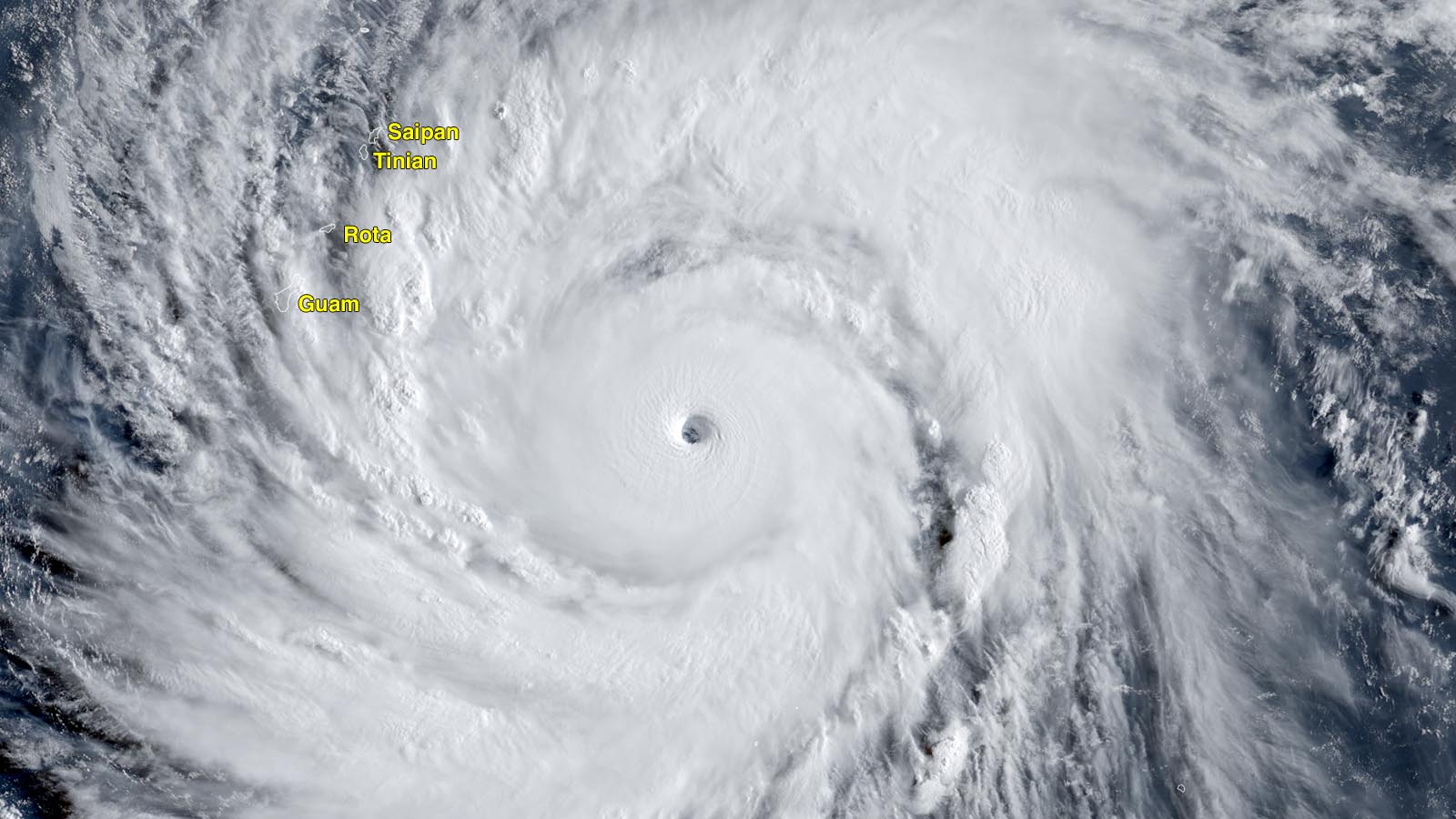
The northwest Pacific is already off to an intimidating start: the second-strongest typhoon ever observed so early in the year, Super Typhoon Sinkalu, rapidly intensified into a Cat 5 with 175 mph (280 km/hr) winds on April 12, 2026, in the waters a few hundred miles southeast of Guam. Sinlaku caused catastrophic destruction across the Northern Mariana Islands, particularly on Saipan and Tinian, after making landfall as a Category 4 storm with winds of 145 mph (230 km/hr) on April 14. Sinkalu also caused heavy damage of over $435 million on Guam. For the season so far, the northwest Pacific has seen four named storms, one typhoon, and one major typhoon. The 1991-2020 averages for this point in the year are 2.5 named storms, 1.2 typhoons, and 0.8 major typhoons. The ACE index is currently 190% of average.
Read: ‘We didn’t lose each other:’ How people are picking up the pieces after Super Typhoon Sinlaku

El Niño-boosted typhoon seasons
The northwest Pacific typically sees a boost in typhoon activity during an El Niño event, largely from warmer waters that are displaced farther to the east. During El Niño years, typhoons take longer tracks over water before hitting Asia, resulting in a greater chance of becoming major storms.
The El Niño year of 1997 saw a record number of Category 5 storms in the Northwest Pacific — ten, along a record ACE index of 594. At one point on October 17, 1997, Super Typhoon Joan had top sustained winds of 185 mph (295 km/hr), while Super Typhoon Ivan had top winds of 180 mph (290 km/hr) — the only time on record that Category 5 storms of such extreme intensity existed simultaneously (Fig. 1).
Bob Henson contributed to this post.
![]()